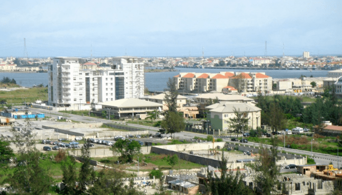
To investors, Eti-osa is an investment destination as the region’s real estate potentials continue to grow. Due to studded development in the area, the region is critical to Lagos’ image as the centre of excellence. But not many are concerned about what it once was and what it is now.
Documents recently extracted from the national archives have revealed stunning information about the history of the Eti-osa Local Government in Lagos and questioned the current geographical structure of the area.
The area of land in Lagos State known as Eti-osa Local government encompasses Ikoyi, Victoria Island, Lekki Phases one and two, all the way down to Ajah, and ends in Sangotedo. It also includes Addo, Langbasa and Badore in the Ajah area.
Eti-osa accommodates the most affluent Nigerians and is probably the most prosperous area in Lagos today. However, it was not so from the beginning. In fact, it was the poorest part of Lagos, up till recent times.
An intelligence report on the Eti-osa area of the Lagos colony, carried out in 1949 under colonial rule by a district officer, known as T.F Barker, describes the area as, “a tract of land between the lagoon and the sea beach fiftytwo square miles in the extent of which the western boundary runs northwards from the sea about three miles from the East mole of Lagos Habour.”
The earliest historical reference to the area is related to Efunroye Tinubu, the 19th century woman of influence, who created outposts along the coasts of EtiOsa for her thriving slave trade.
Read Also: Lagos stops land extension into Banana Island, Osborne Foreshore Lagoon
Tinubu’s outposts included Lekki and La Palma (Orimedu). In those days, the interior of the area was for all intents and purposes, inaccessible and was indeed, so described until 1937 when it became known as the Addo area. The name, Eti-osa, meaning, ‘ by the Lagoon’, was given to it by a reverend, Thomas Adeshina Jacobson Ogunbiyi, under the British colonial government.
Barker, who later became the governor of Lagos described the prevalent conditions of the area as:
“Owing to its inaccessibility and its lack of roads, both factors which are likely to persist for many years to come, the Eti-osa area remains one of the few districts which cannot be satisfactorily toured unless rest houses are provided.”
According to Barker, to bring development and civilisation to the area, a meeting was held in May 1949 to determine whether Eti-osa should be governed as an independent native authority or brought under the Ikeja Division, the most prosperous part of Lagos at that time.
For instance, Barker’s report states that in the West (of this territory) there are wide expanse of barren marshland where nothing grows but reeds and coarse (tall) grasses. The triangle of marsh between Maroko (Sandfill), Gedegede and Ogoyo (no longer in existence) which has been included in the Government anti-malarial drainage scheme as the ‘Ilado swamp area’ should soon provide (then) a valuable square mile or two for planned utilization, and the adjacent marshland extending eastwards to Ajiran offers opportunities for development when drained.
These marshlands described above are no longer in existence as they have been filled and converted into habitable areas now containing upscale residential estates.
He further describes a waterway, which was an extensive swamp that is a continuation of the inlet from the lagoon between Ajiran and Aja, eastward past Ikota, and eventually into the Epe division of Lagos, which included Ibeju-lekki.
“This waterway, though not marked on published maps, is of considerable local importance…” he noted.
From logical evaluation, the massive swamp described above may have been the area now currently occupying several popular estates including the Chevron Drive and the Victoria Garden City (VGC).
Farther to the east, patches of high forest once stood but these have long been destroyed, as claimed by Barker.
The evidence of this massive forest described by Barker can be seen today all over Eti-osa as remnants of thick forests remain behind the Jakande Housing Estate and the Lekki Conservation Centre, being managed by Chevron oil and gas. The presence of this forest also lends credence to the origin of Igbo Efon, said to be founded by a hunter and named, ‘Forest of Buffalos’ (meaning of Igbo-efon in Yoruba).
Barker’s intelligence report also includes an old map of Eti-osa with territories of major communities in the area clearly delineated. This map, however, sharply contrasts with the prevailing reality of the area today.
The map begins with Sandfill formerly known as Maroko, on the westernmost boundary of the land, and the current territory of the Oniru of Iru land.
Next to Maroko on the South Eastern side, was Maiyegun, with a territory that extended eastwards, through the areas that today, include the Jakande Housing Estate, all the way to Igbo Efon, its Eastern neighbour.
Maiyegun was bordered in the North by Igbokusu. Igbokusu was on the North-east of Sandfill, on the banks of the lagoon, with a large expanse of land filled with marshes that extend all the way to Ikota and Aja. It had both Maiyegun and Igbo Efon to its South.
Igbo-efon, a settlement located within what used to be a thick forest filled with Buffalos, had Maiyegun on its Western border and extended Eastwards to Ogombo, with Igbokusu as its Northern neighbour. To its South was Okun Alfa.
Ogombo shared an eastern border with Sangotedo, the easternmost settlement in Eti-osa. North of Ogombo, there were several settlements indicated on the map which today are known as the Aja area. They include Iranla, Oke Ira, Addo, Badore, Oshodi and Langbasa. This part of Eti-osa has remained largely unchanged, compared to the Western part.
Okun Alfa and Okun Aja, which are almost non-existent today because of the encroachment of the Atlantic Ocean, mark the southernmost reaches of Eti-osa.
Once the outback of Lagos, Eti-osa has become the prime real-estate destination of Nigeria, and the location of some of the largest corporate organizations in the country. Due to the buildup of population, construction of infrastructure and modern buildings in the area, Eti-osa looks very much different from 70 years ago.
There are even smaller settlements, according to reports, that have either been subsumed in the encroaching civilization or have been relocated to other parts of Lagos. This transformation continues today and will go on for a long time.

Join BusinessDay whatsapp Channel, to stay up to date
Open In Whatsapp