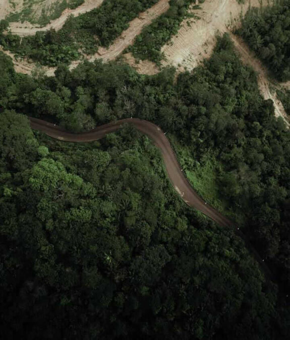
If you’ve ever driven into Enugu from certain directions, you’ve met Milliken Hill without necessarily knowing its name. It’s the winding stretch of road that curves along the edge of the city, with trees leaning in on one side, and the Coal City opening up beneath you on the other.
For a lot of people, it’s the first real view of Enugu they ever get, and that’s not an accident of geography.
Milliken Hill has long served as one of the city’s defining gateways: a corridor that residents, cyclists, skaters, hikers, and photographers pass through regularly, and one that visitors are often pointed toward for a proper look at the terrain that gives Enugu its character. It’s less a road than a vantage point.
Few places in the state offer that particular combination of scenic beauty and geological drama in one sweep.
More Than A Line On A Map
Say you’re driving into the city on the old Enugu–Onitsha Expressway, off the present-day Enugu–Makurdi Road, on paper, you enter Enugu State the moment you cross the Oji River boundary with Anambra. That’s the gateway, in the strict planning sense: a legal line, nothing more. It could be any border crossing anywhere, really.
Nobody actually feels that line. What they feel comes later, past 9th Mile after the town of Ngwo, where the road narrows and starts to climb and the forest closes in on both sides. And then, at Milliken Hill, it all lets go at once: the canopy breaks open and the entire Coal City spreads out below, and you can feel an exciting sensation in your chest.
Planners have a language for this, and it’s worth borrowing: a vista point — a natural lookout where the view suddenly opens; the view terminus — the payoff your eyes land on at the end of that view, and in this case, the skyline itself; a “psychological threshold” — the exact moment your brain registers that you’ve left one place and arrived somewhere else.
Milliken Hill is, more or less, a textbook case of all three happening at once, like a rush of blood to the head, a literal initiation into Enugu. The city has one legal gateway on this route and one real one, and they are not the same place.
It’s worth noting there are sixty-seven official entry points scattered across the state in total — seven of them major road gateways, alongside two rail gateways, one air gateway, and a single historic river port. Technically, Milliken Hill isn’t different from any of those. It’s really just the one nobody forgets.
How It Came To Be
The hill predates the road, obviously, but the story most people know starts in 1908, when a British expedition travelling from Awka toward the middle belt passed through Enugu Ngwo and reported the site back to colonial authorities in Lagos.
The following year, a team of mining engineers was sent to prospect for silver. They found coal instead — and that discovery is what put this particular stretch of land on the map. The colonial administration settled at the top of the hill, in what’s still known locally as Hilltop, to oversee the new mining operations at Iva Valley, Onyeama, Ogbete, and Okpara.
Getting people and material down from that settlement to the city below required a road, so in 1909 colonial engineers led by WJ Leck carved one out of the hillside: roughly 4.8 kilometers long, with somewhere between 28 and 33 sharp bends depending on who’s counting, cut directly into the rock along a deep gully.
It was named Milliken Hill Road after the principal engineer A.B. Milliken, a British colonial engineer who designed and supervised the construction of the famous winding road whose name is permanently attached to the landmark is.
Also William John Leck, who now has Leck Avenue located in the Government Reserved Area (GRA) named after him, was the chief British mining engineer who led the team of coal miners and immigrant settlers into Enugu to develop the mines.
For decades afterward, it was the only route in and out of Enugu from that direction — used by British officials, miners, and civil servants moving between the coast and the inland mining town, and later, during the Second World War and the independence movement, by troops and supplies passing through the region.
It stayed the sole route into the city for a long time, which also gave it one of the state’s higher accident rates given how sharply it winds. The road wasn’t reconstructed at all until 2018, under Governor Ifeanyi Ugwuanyi’s administration — the first real infrastructural attention it had received since the colonial government first built it more than a century earlier.
Where It Sits
Geographically, Milliken Hill is the third highest of the capital’s major distinct high zones. The whole western boundary technically belongs to a single escarpment — the Udi Hills — but locally, the landmarks and vantage peaks break down roughly like this:
With Elenkwu and Ngwo Heights representing the actual ceiling of the state, sitting at 592m and 589m respectively, both resting on the highest spine of the Udi-Nsukka Plateau.
We Step Down as you move toward Enugu City, the land takes massive architectural steps downward. Ikirike Hills, sitting at 480m forms a massive upper wall, while Milliken Hill, known to the locals of Ngwo by the name “Ugwu Miriki” elevates up to 330m sits on a lower ledge right where the plateau breaks sharply into the valley. The Low Plain (Rank 5): Ede Hill at 310 m sits entirely off the main plateau structure, acting as an isolated mound on the low-lying plains.
What It Could Still Become
Just like you have the Iron Lady, also known as the Eiffel Tower in Paris, and the Statue of Liberty for New York as the anchor landmarks for these locations, picture an Iconic pavilion or beacon of some sort at the crest, something modest and well-built. A rail to lean on, a bench, maybe a plaque with some of this history on it. Somewhere a driver could actually pull off, step out, and stand still for five minutes instead of catching the view sideways through a windshield at thirty kilometers an hour. That’s it. That’s the whole ask.
It’s a strange gap, when you think about it: a road that connects the untouched green of the Ngwo Pine Forest to the buzz of the State Secretariat, that gives every arriving visitor their first look at the city, still gets treated as pure infrastructure — just a way to get from A to B — rather than the landmark it clearly is.
The truth is, Enugu doesn’t lack scenery. It just has never built anything to hold this particular view. But with small, deliberate investments, Milliken Hill could be the reason people plan a stop in Enugu, not just as the road they happen to pass through on the way to somewhere else.
A landmark’s significance doesn’t protect it automatically. Milliken Hill carries decades of history and a fair amount of civic pride, and it’s still, at the end of the day, a shared public space, which means its condition depends on how the people around it choose to treat it.
That tension — between what the hill represents and what’s actually happening to sections of it — is where the next chapter of this story picks up. For now, we just wanted to introduce it properly: this is Milliken Hill, one of Enugu’s most iconic landscapes, and the reason this newsletter exists.

Join BusinessDay whatsapp Channel, to stay up to date
Open In Whatsapp